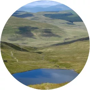
Ysgyryd Fawr
| Use attributes for filter ! | |
| Elevation | 486 m |
|---|---|
| Prominence | 344 m |
| English translation | Great shattered |
| Pronunciation | Welsh |
| Topo map | OS |
| Parent range | Black Mountains, Wales |
| Ratings | 4.9 |
| Pronunci | Welsh |
| Parent rang | Black Mountains |
| Coordin | 51°51′30″N 2°58′15″W / 51.858386°N 2.970816°W |
| English translat | Great shattered |
| Date of Reg. | |
| Date of Upd. | |
| ID | 842533 |
About Ysgyryd Fawr
Skirrid Fawr, often referred to as just the Skirrid, is an easterly outlier of the Black Mountains in Wales. It forms the easternmost part of the Brecon Beacons National Park. The smaller hill of Ysgyryd Fach or "Little Skirrid" lies about 2½ miles to the south.
Where is the Ysgyryd Fawr
Click on the photo of Ysgyryd Fawr to view it on Google Maps.