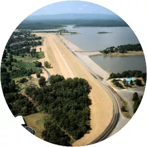
W D Mayo Lock And Dam 14
| Use attributes for filter ! | |
| Length | 2. 256 km |
|---|---|
| Construction began | May 1966 |
| Impound | Arkansas River |
| Operator | United States Army Corps of Engineers |
| Normal elevation | 413 |
| Locations | Oklahoma |
| Date of Reg. | |
| Date of Upd. | |
| ID | 2619709 |
About W D Mayo Lock And Dam 14
The W. D. Mayo Lock and Dam on the Arkansas River is an integral part of the McClellan-Kerr Arkansas River Navigation System. The dam is located at navigation mile 319. 6, about 9 miles southwest of Fort Smith, Arkansas. It is the first lock and dam west of the Arkansas-Oklahoma state line.