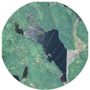
Chamberlain Lake
| Use attributes for filter ! | |
| Area | 4424 |
|---|---|
| Max depth | 47 m |
| Surface elevation | 287 |
| Locations | Piscataquis County |
| Maine | |
| Max. length | 14 mi (23 km) |
| Water volume | 473,380 acre⋅ft (583,910,000 m3) |
| Date of Reg. | |
| Date of Upd. | |
| ID | 1970694 |
About Chamberlain Lake
Chamberlain Lake is one of the largest and deepest lakes in the North Maine Woods. The lake originally drained north through Eagle Lake and Churchill Lake into the Allagash River tributary to the Saint John River.