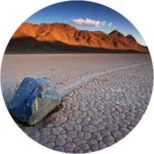
Badwater Basin
| Use attributes for filter ! | |
| Surface elevation | 85 |
|---|---|
| Length | 12 km |
| Width | 8 km |
| Locations | Death Valley |
| Inyo County | |
| California | |
| Cities | Badwater |
| Did you know | At Badwater Basin, significant rainstorms flood the valley bottom periodically, covering the salt pan with a thin sheet of standing water. |
| Date of Reg. | |
| Date of Upd. | |
| ID | 1056196 |
About Badwater Basin
Badwater Basin is an endorheic basin in Death Valley National Park, Death Valley, Inyo County, California, noted as the lowest point in North America, with a depth of 282 ft below sea level. Mount Whitney, the highest point in the contiguous 48 United States, is only 84. 6 miles to the northwest.